Mention “the wall” when I was at school, or in adolescence, and we all thought China, Berlin or indeed some, Pink Floyd! But for me, it was always ‘Adrian’s Wall. We had a history teacher who filled our head with the Roman conquest, Caesar and Caligula, and as he dropped his ‘aitches’, ‘Adrian! So it was ‘Adrian who in 122 AD built a wall right across the top of ‘Britain’, over seventy miles long, just to keep out the Barbarians and I envisaged a structure as high as the Wailing Wall which I had only seen in pictures. And that, was bloody high! As a fit and strapping lad, who reeled back the miles in his step in those days, I pledged myself to one day walk ‘Adrian’s Wall, right across the country and beard the Barbarian myself. Years later, I remember a then relative telling her husband that there was no way she would travel “all that way up north to see a pile of old rubble”, and I laughed when he castigated her as a distinctly out-of-place Philistine! By then, I had read more about Hadrian’s Wall and my dream hadn’t dimmed. In company with my sons, I would walk it, but when they couldn’t, my brother, was enthusiastic, but then when he couldn’t, I planned on alone! Ahh, but I was younger then!
From the solid sandstone market town of Penrith, we set out to cross England’s ridge-back, the Pennines, but not before provisioning at John and James Graham’s wonderful Family Grocers, Est 1795, with its wonderful local breads, cheeses and chutneys. It was not till I stepped outside to photograph the picturesque sandstone façade that I saw in the brickwork Agricultural seed, cake and manure merchants. “They’d probably do a good ‘shit sandwich’ in there” I said to my wife. Like Victoria, she was not amused! Even less when we incurred a parking ticket!
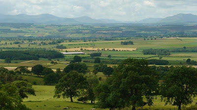
Climbing through the Pennines and looking back to the Lakeland Fells
The road through the Pennines twisted upward in a long series of switchbacks and hairpin bends, climbing gently upward, an almost constant file of motor-cycles and bicycles going slowly in one direction, or hurtling down at speed the other way. It was only when we crossed the Alston Moor and drove up Alston’s steep cobbled main street, with its church and market cross at one end, and saw the town full of lounging lads in leather and lycra, that we realized that this was the mid-way point of the “Sea to Sea cycle route”. This quaint seventeenth century market town, at 1000 feet the highest market town in England, is a veritable mid-air refueling stop, and we joined the throng for a bitter and “the finest pasties in the north of England”!
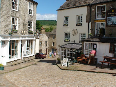
Alston, the highest market town in England
We pressed on across the heather clad moor, now a dullish green, but soon to be a blaze of purple. There was the occasional smokestack, from the days when lead mining and its poisonous fumes took its toll on humans, vegetation and livestock alike, and I shuddered at the thought of sickness in this, the bleakest of landscapes. We were glad when we found the large market town of Hexham on the River Tyne. Here, I felt, I could smell the Romans! Indeed, they had been here, albeit largely in a proxy capacity. Some of the stones from Hadrian’s Wall had been used in the original 674 AD St Wilfrid’s Abbey, till much was destroyed by the Danes in 821. The Hexham Abbey which now stands in the same spot, dates from the Eleventh Century, and there is a fine Fourteenth Century covered market and a 1330 gaol, the fore-runner of ‘modern gaols’ that were no longer dungeon hell-holes. Being close to the land of the Barbarians, the Scots were often in town; sacking and pillaging, William ‘Braveheart’ Wallace in 1297, sparring-for-a-fee Robert the Bruce in 1312, and frequent Border Reiver raids. Then there was the Battle of Hexham in the 1464 Wars of the Roses and the Hexham riots of 1761, so it was a place which saw a lot of action in between making leather gloves, Hexham hats, and running mills on the rushing Tyne. But now I felt the call of the wall and after a peruse and a pint, we headed north
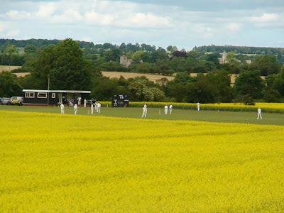
The playing fields of England; club cricket near Hadrian’s Wall.
Near Chollerford, just before we came to locals playing cricket on a patch of green amid a field of mustard seed, we saw a sign to the Wall, but passed on with nary a glimpse as it was hidden in a thicket as it probably had been for much of its nearly 2000 years. Tomorrow it would be my day, for I planned to walk from the famed Steel Rigg to the old Roman settlement at Housesteads, and I had yet to prepare my ‘survival’ pack, and read again the guidebook. Just follow the wall east, no chance of getting lost, the wind at my back, fellow walkers to nod to, sheep and sights to photograph, between three and four miles, easy peasy! Like a Legionnaire, I would keep a hawk like eye peeled to the north, and any coming by those Pictish Scots! But first I had to rest up at the picturesque Battlesteads Hotel in the tiny village of Wark, a place first mentioned in the Eighth Century, and only ten or so miles from the Wall. Maybe I could put my feet up for a while and maybe, just maybe, my wife would give me a foot massage with soothing oils. Then again…
Now before we embark on my personal feat/feet, first a little background. Old 'Adrian actually came up here in 122 AD, swept his hand over the valleys and ridges and said "Build a wall there, guys" and in the short space of six years it was done, there being no union delegates or shop-stewards to say "Now hang on a minute, Emp!" Mind you, the Shoppies had probably learned their lesson when twenty years later, Emperor Antoninus Pius said "No guys, it is in the wrong place", and had another cross-country wall built between the Firths of Clyde and Forth. That one was just 39 miles long, took twice as long to build, and somehow the Antoinine Wall – now largely disappeared – doesn't have the authoritative ring of 'Adrian's Wall.
Just imagine the organization involved, gathering all those stonemasons and other artisans, planners and inspectors, building roads to bring in supplies and food, constructing store-houses and granaries! Not that labour or raw material was much of a problem as stones and serfs abounded, and I guess that they didn't require lodgings in villas with under-floor heating, bath-houses with spas and saunas, and self-flushing loos! There was even a Temple of the Nymphs at Vindolanda, suggesting opportunities to roam away from home, and engage in a little hanky-panky! The settlements at Chesters, Housesteads and Birdoswald showed comfort was a priority in the desolate landscape. Then too, but for the efforts of a Nineteenth Century real life Indiana Jones, one John Clayton, much of the wall would have been "Pict" clean, and more bits of it would have disappeared into houses and buildings. Clayton bought up vast tracts of land and though a lawyer (yes, there are compassionate ones!), pursued archeology with an admirable zeal and in fact, "saved the Wall". Since 1987, it has had World Heritage listing.

Foxgloves against Hadrian’s Wall
On a tungsten grey morning, when the wind gusted at 50 kph, we drove to Once Brewed, a place that sounds like a tea bag, where the National Trust has an outpost. From there, informed and fortified, we went to the car park at Steel Rigg, a place which sounded as though it should have been sponsored by BP! At the top of the ridge, the car rocked like an aircraft over the Himalayas, and as I opened the car door, I thought for a brief moment of Captain Scott at the tent flap in Antarctica! I was glad too, that my day pack was weighed down by all manner of goodness and sustenance, otherwise I am sure that I would have taken flight and possibly had to circle Housesteads until my wife arrived to pick me up! I went to touch my nose but the wind blew my hand into a wave, and she waved back, but her look simply said, "Silly bugger!"
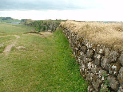
My starting point: Whin Sill with Crag Lough seen from Steel Rigg
I made my first acquaintance with the Wall mere minutes after leaving the car-park, and while it bucks and wheels on the barren ridges, looking like a Mowhawk haircut, up close it is mildly like a disappointing blind date, not very tall and somehow a little to thin! Only at chest height in many parts, you can easily look over it, and sometimes not more than two metres wide so that if Pamela Anderson and Dolly Parton were guarding it and tried to pass, side on, one of them would surely be bumped off! But then it was never meant to be an insurmountable wall to humans. It was a barrier to stock thefts and pillaging, in that the exit gates were choke points and heavily guarded. Furthermore, in Roman days it would have been crenellated, with regular foot-patrols and re-enforcements at every mile in the appropriately named Mile-castle mini barracks. It runs along territory where you can see for miles, and any gathering of Barbarian marauders would be quickly spotted, and along would come a whole phalanx of the boys with flashing helmets, stumpy swords, oblong shields, and the Kevlar of its day, the Roman breast-plate.
As the crow flies, the distance of my walk was three miles, which is fine for crows, but for me, there were more ups and downs than you'd find in a bordello on a busy night, thighs and calves straining, breathing laboured, but boy it felt good to get up and over steps or stiles. I took out my hearing aid, which made me feel as though I was inside an actual jet engine, but the cold wind made ears and joints ache, and tears form. And this was summer! Once or twice, I really feared being blown over a cliff and shaped myself like an armadillo, scuttling along the path of big stone blocks, praising the dear souls who had made the paths, as walking on the Wall was not permitted. The views, when I could see them, were spectacular, from green horizon to green horizon, and all in between green and woolly, sheep like spots of dandruff, with the occasional solid grey-stone farm, and the arrow-straight path of the Roman military supply road, which ran way below. And amid the ever-present sheep dung, the bright pink of the thistle and the foxgloves were the only suggestions of nature's softness.
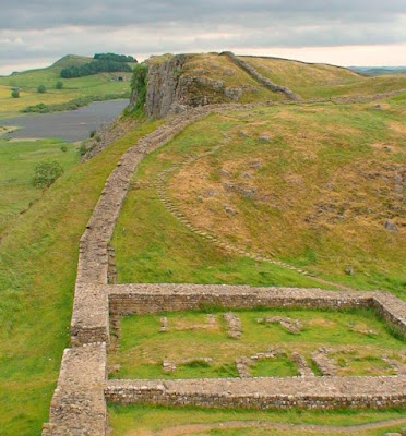
Mile-castle (foreground) and Whin Sill above Crag Lough
Beyond my first Mile-castle, I dipped down to the famous sycamore tree, now better known as the 'Robin Hood Tree' when a clearly disoriented Kevin Costner (Sherwood Forest, Nottingham is two hour's drive south!) used it in his film, Robin Hood, Prince of Thieves. It was but a temporary respite. On top of the cliffs at Whin Sill, the lake of Crag Lough looked like molten steel, fresh from the furnace, a surface white froth that dissipated in seconds, but further along there was a sheltering woodland and it was wonderful to find temporary sanctuary from the incessant wind.
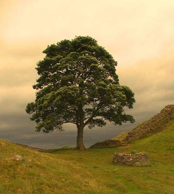
The Sycamore Gap tree which is better known as ‘The Robin Hood Tree’
Again I plodded downward, then upward again, and over stiles near Hotbank farm, horses watching my laboured assent to yet another ridgeline. Over a small ridge came a small red, white and blue Norwegian flag, followed a mili-second later by a huge back-pack, then the baseball cap on the head of a stout woman, she in huge hiking boots, shorts and a tee shirt! A Norse through the gorse, a hiking Viking, with those ruddy cheeks and the clear eyes of the uber-healthy, Aquavit probably in her veins, and of course a hail and hearty "good morning", without breaking stride. For a moment, in the coldness, I wished I’d had the foresight to bring a hip flask! There were others like her further along, but none so scantily clad, yet all were focused and determined, alone or in pairs, with guidebooks or Ordinance Survey maps held like a fair-ground entry ticket.
The Cuddy Crags are claimed to be the most ‘scenic’ part of Hadrian’s Wall, and with Broomlee Lough in the distance, the land of the Barbarians looked at peace, belying its turbulent past. Below me lay Housesteads, neatly laid out stones showing the foundations of buildings in a once major encampment. I turned right, giving the Wall a farewell pat, just as spatters of rain started, and at another National Trust outpost, I had a warming coffee, bought postcards and looked at the jumble of arrayed books, plastic swords and breastplates. Feeling like George Dubya on the aircraft carrier, USS Abraham Lincoln, I sat down at a table and wrote to my relatives, “Mission Accomplished”. Never mind that like George, I still had miles to go! I had fulfilled a childhood dream, ‘walked ‘Adrian’s Wall, and walked in the steps of the Romans. I really did feel on top of the world, and a short while, I was as far north as the might of Rome had reached.
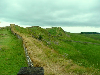
Hadrian’s Wall at Cuddy’s Crags, looking back along where I had walked.
With windscreen wipers tangoing, my wife drove into the car park, followed by three huge busloads of ‘day legionnaires’, many armed with cameras, others no doubt ready to try on breastplates and plastic amulets, a cacophony of screeching and laughter as they sought shelter from the rain, or just the loos. My venture along Hadrian’s Wall had been peaceful, with just the shrieking wind and the occasional bleating of sheep for company, and I preferred it that way. But as we drove back to Wark, I kept looking to my left, and the Wall, as it followed the ridgeline. It was good to witness history up close and personable, but it was a darn sight more comfortable, and warmer, to also be along for the ride!
Winfred Peppinck is the Tales of the Traveling Editor for Wandering Educators
All photos courtesy and copyright Winfred Peppinck.
This is part of Photo Friday at Delicious Baby! Head over there to view photos from around the world.
