Yesterday I hiked up at Broken Top, in Bend, Oregon. It was a gorgeous day - here are some of my photos! I hope you enjoy the virtual hike!

Broken Top mountain, as seen on the way up to the trailhead, from the forest service road.

First crossing of the runoff, 15 minutes into the hike. Wildflowers on the side in purples, reds, and blues.

Where I headed (to the right of that "V" glacier in this picture), this is the East side of Broken Top

Hiking through the rocks, next to a glacier, up into the cut to reach the tarn.

Flow from the tarn (which is about 15 vertical feet above) driving down and under the glacier (as seen in the above picture).

The tarn, with ice/glaciers still in it, more than I've previously seen. You can see this is on the side of Broken Top. Maybe you can even see a little of the spectacular colors in the rock; they are brilliant yellows, reds, oranges, and greys.

Icebergs in the water

SUPER cold water, icebergs in it, or glacial ice, this is looking back to where that water was flowing out, to the left in this picture.
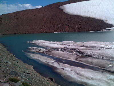
The icebergs/ unmelted glaciers in the tarn.

More of the tarn (above), looking the opposite direction. I'll hike up the glacier in the center, and then up the ridge to Broken Hand.

The Three Sisters: Charity, Faith, and Hope, or South Sister, Middle Sister, North Sister (L-R), seen from my lunch break spot right next to Broken Hand. Yup, my lunch time view!

N. Sister, Mt. Washington, Three Finger Jack, and Mt. Jefferson - all in the distance.

Colors, and you can see the drop! and the land below, meadows, lakes, trees, and glaciers.

The tarn from above, enter and exit around the corner, by where the open water is. This is where the water flows out and down under the next glacier down.

Broken Hand as seen from a little way down the ridge. I had my lunch break up there!

The trail on the way down, with Mt. Bachelor in view. Hiking is on our dirt/ pumice. The path is well defined, but people (like me!) still put up cairns.
I hope you enjoyed this trip as much as I did! Oregon is just full of great hiking opportunities, and extraordinary scenery.
For more information on the geology of Broken Top Volcano, please click here to go to the US Forest Service's information page.
For more information on Broken Top, including descriptions and maps, please click here to go to the US Geological Survey's information page.
Ben! Voigts
Pacific Northwest Editor, WanderingEducators.com
All photos copyright Ben Voigts